In the Mail: 7 Postcards Explore Nature and Landscapes Along Route 66
In the Spring and Early summer of 2025 as I worked with the National Trust for Historic Preservation to transcribe and map a collection of over 3,000 historic Route 66 postcards from the Newberry Library, it became clear to me that nature and landscape constitute more than just a passive backdrop through which Route 66 passes. In a concrete sense, natural sites were significant draws for Route 66 tourists, actively shaping the flow of traffic and commerce along the route.
In a more profound sense, many of the landscapes found along Route 66 have woven their way into our collective imagination, often appearing in places like travel magazines, road trip and vacation movies, and other forms of cultural media that shape perceptions about what nature is, what kinds of natural things are worth seeing and protecting, and what kinds of activities are ideal for tourists to do.
Below is a list of seven natural sites along Route 66 that appeared frequently in the Newberry postcards. Not only do they make excellent fodder for a road trip wish list, they can also provide a glimpse of how tourists encountered and interacted with nature as they traveled along the Mother Road.
1. Forest Park (Missouri)
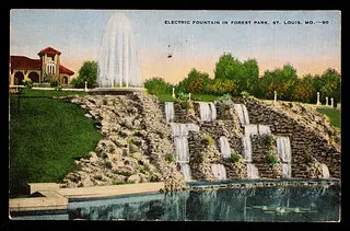
photo by: Newberry Library
Front of Forest Park postcard.
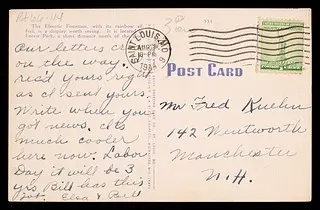
photo by: Newberry Library
Back of Forest Park postcard.
Currently the largest park in St. Louis at over 1,300 acres (larger than New York City’s Central Park), Forest Park was created in 1874 after narrowly winning approval from local voters. Shortly after, the St. Louis Board of Park Commissioners began constructing roads, paths, bridges, lakes, gardens, and other amenities to make the park accessible and enjoyable for visitors. This entailed significant alterations to the park’s natural ecology. All the park’s lakes, for example, are artificial, initially filled with water from the River des Peres, which was buried beneath St. Louis in 1920 after years of periodic flooding.
The park is also highly landscaped and planted with both native and non-native plant species. Despite this, Forest Park remains a place of refuge for local residents and travelers alike, many of whom come both to enjoy the outdoors and to visit the park’s many museums and cultural attractions. These include the St. Louis Art Museum, the Jewel Box greenhouse and arboretum, the “Muny” outdoor theater, and the World’s Fair Pavilion.
2. Meramec Caverns (Missouri)
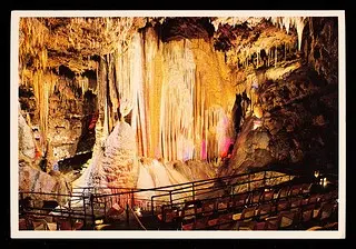
photo by: Newberry Library
Front of Maramec Caverns postcard.
photo by: Newberry Library
Back of Maramec Caverns postcard.
Formed over several hundred million years through the gradual erosion of ancient underground limestone, and used as a refuge from severe weather by Native Americans for generations before the arrival of Europeans, Meramec Caverns was a major attraction along Route 66 and remains a popular tourist destination to this day. Much of this has been achieved through marketing. At 4.6 miles long, Meramec Caverns is not “the largest cave west of the Mississippi,” as its website claims. Nor is it the largest cave in Missouri. That title belongs to the 31-mile-long Crevice Cave.
Nonetheless, untold amounts of visitors have lined up to see the caverns over the decades since local entrepreneur Lester Benton Dill purchased them from Charles Ruepple in 1933 and opened them to the public. An early adopter of the bumper sticker, Dill would send out workers to attach stickers advertising the caverns to visitors’ parked cars. He also drew in tourists by painting advertisements on barns and other local infrastructure, and by perpetuating the legend that famed outlaw Jesse James once used the caverns as a hideout. While evidence for this claim is shaky at best, James was likely part of a band of Confederate soldiers that bombed the caverns during the Civil War when they were being used as a saltpeter mine to manufacture gunpowder for the Union Army.
3. Ozark Mountains (Missouri)
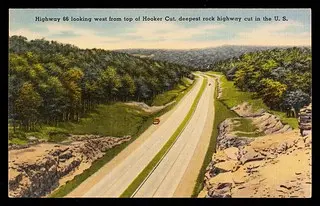
photo by: Newberry Library
Front of Ozark Mountains postcard.

photo by: Newberry Library
Back of Ozark Mountains postcard.
Spanning much of southern Missouri, northern Arkansas, and a sliver of eastern Oklahoma, the Ozark Mountains, an eroded plateau uplifted during the assembly of the supercontinent Pangea, form part of the largest mountain region between the Rockies and the Appalachians. While not as high and rugged as either of those ranges, the Ozarks’ domed peaks, high plateaus, deep valleys, and sprawling cave systems (including Meramec Caverns) captured the eyes and hearts of many a tourist during Route 66’s heyday.
Not only is the beauty of the Ozarks frequently mentioned in messages written by Route 66 travelers sending postcards to their loved ones, its landscape is also the main subject of much Route 66 postcard imagery. In particular, postcards featuring landmarks such as Pacific Bluff, Devil’s Elbow, and Hooker Cut (featured below) paint a picture of the journey along Route 66 as one steeped in natural splendor.
4. Sandia Mountains and Tijeras Canyon (New Mexico)
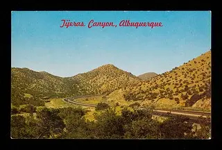
photo by: Newberry Library
Front of Sandia Mountains postcard.

photo by: Newberry Library
Back of Sandia Mountains postcard.
The first large mountain range Route 66 travelers going east to west would have encountered since departing the Ozarks, the Sandia Mountains serve as both a backdrop for one of the route’s key urban destinations (numerous postcard images of Albuquerque are framed to capture the Sandias looming behind the city) and an introduction to the Mountain West. Motorists driving toward Albuquerque from the east along old Route 66 (now Interstate 40) can begin to make out the Sandias’ soaring granite and limestone peaks, uplifted 7-10 million years ago during the Rio Grande Rift, as they approach the town of Moriarty.
Shortly afterward, motorists enter Albuquerque via Tijeras Canyon, which forms the boundary between the Sandia Mountains to the north and the Manzano Mountains to the south. A favorite subject of Route 66 postcard image makers, Tijeras Canyon continues to maintain its historical connection to Route 66. Sections of the route through the canyon are still drivable, and in 2014 one of these sections was outfitted with rumble strips that vibrate to the tune of “America the Beautiful” if one slows to the speed limit before driving over them. It seems that the connection between nature, travel, and nationalism along old Route 66 is still very much alive.
5. Painted Desert and Petrified Forest (Arizona)
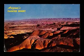
photo by: Newberry Library
Front of Painted Desert postcard.
photo by: Newberry Library
Back of Painted Desert postcard.
As motorists drive along old Route 66 through northeastern Arizona’s badlands, they will likely notice a peculiar phenomenon occurring on the landscape. The farther west they go, the beiges, tans, and browns that characterize New Mexico’s Bluff Country to the east give way to a wider array of colors, including deep oranges and reds, bright silvers, even blues and purples.
This is Arizona’s Painted Desert, a region of the Colorado Plateau characterized by exposed shale, siltstone, mudstone, and other layers of the Chinle Formation—a group of sedimentary strata formed over 200 million years ago when the region was covered by a large tropical river system. High concentrations of iron and manganese compounds within these strata are responsible for the diverse hues that define the Painted Desert.
In the Painted Desert’s southern reaches, Petrified Forest National Park (previously Petrified Forest National Monument until 1962) protects an area of badlands peppered with permineralized trunks and logs from ancient trees, many of which are now extinct species. Geologists have determined that these remnants of the tropical forests that once covered the area were at some point rapidly buried by volcanic ash, preventing them from decomposing. Over time, mineral-laden water seeped through the ash and into the pores of the buried trees, replacing their organic matter with crystals to create stunningly accurate casts of their internal and external structure.
Route 66 Postcard Road Trip

Explore the evolution of historic Route 66 through maps & place-based data.
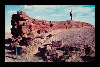
photo by: Newberry Library
Front of Petrified Forest postcard.
photo by: Newberry Library
Back of Petrified Forest postcard.
A place where the enchanting strangeness of the American Southwest can be seen on full display, it’s no wonder that Petrified Forest and the Painted Desert are featured on so many Route 66 postcards. Nor is it surprising that both are frequently discussed alongside the Grand Canyon in messages written by Route 66 travelers as being one of the most memorable portions of their drive through Arizona.
6. San Francisco Peaks (Arizona)
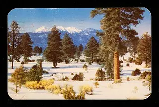
photo by: Newberry Library
Front of San Francisco Peaks postcard.
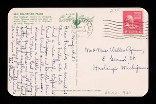
photo by: Newberry Library
Back of San Francisco Peaks postcard.
The San Francisco Peaks are a small range of high mountains whose jutting summits can be seen by Route 66 travelers approaching Flagstaff, Arizona from either the east or the west. Remnants of what was once a large stratovolcano that reached altitudes even greater than their current high point—Humphery’s Peak at 12,633 ft. —the San Francisco Peaks hold longstanding significance for many local Native American tribes. In Navajo culture, for example, the San Francisco Peaks (called Dookʼoʼoosłííd, or “the summit that never melts”) are one of the four sacred mountains marking the boundaries of Dinétah—the traditional Navajo homelands.
In Hopi culture, the peaks are known as Nuvaʼtukyaʼovi ("place-of-snow-on-the-very-top") and are considered home to ancestors whose spirits have departed to become clouds. The Hopi also use the alignment of the sunset in relation to Nuvaʼtukyaʼovi and their villages on Black Mesa to calculate the winter solstice. These and similar cultural relationships between the San Francico Peaks and other local Indigenous groups, as well as the peaks’ frequent presence in Route 66 postcard imagery, demonstrate how natural features can shape the day-to-day activities, customs, and experiences of humans.
7. Black Mountains (Arizona)
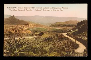
photo by: Newberry Library
Front of Black Mountain postcard.

photo by: Newberry Library
Back of Black Mountain postcard.
The Black Mountains, a range of low igneous peaks southwest of Kingman, Arizona, are home to a scenic stretch of Route 66 nicknamed the Oatman Highway. Along this stretch are several locations featured prominently in the Newberry postcards. Starting from the east, the first is Sitgreaves Pass, a popular lookout along Route 66 mistakenly named after American Explorer Lorenzo Sitgreaves (his expedition likely crossed the Black Mountains via a different pass farther north). From Sitgreaves Pass, the Oatman Highway meanders through the Black Mountains’ rugged desert terrain to Oatman, a historic gold mining town turned kitschy tourist stop with various shops, eateries, and galleries housed in both historic and rebuilt Old-West-style buildings. At the western end of the Black Mountains sits Boundary Cone, a striking rocky promontory that has served as a landmark for both European and Native American navigators for centuries.
Postcard images of these and other locations along the Oatman Highway resemble the kinds of images that might come to mind when one pictures the quintessential southwestern road trip: remote arid mountains, desert scrub, cacti, abandoned mines, a small dusty town or two. It would not be surprising to find that decades of Route 66 travelers passing through the Black Mountains and their surrounds has helped shape popular imagery of the Southwest often seen in TV, movies, and other media. Another example of the ways Route 66 and the landscapes it traverses might continue to inform our collective perception of American nature, history, and geography.
Save Historic Places That Tell Our Full American Story
When you join the National Trust, you help save historic and culturally significant places nationwide.

.webp)