Take A Drive Through The Past On These 4 Historic Routes

photo by: Clarence Holmes Photography/Alamy Stock Photo
Many of the National Road’s milestone markers have been preserved.
In 1806, the first federal road-building program commenced with a goal of creating a reliable route from the East Coast over the Appalachian Mountains and opening up the Midwestern frontier. But government leaders probably never imagined that project would kick off a national fascination with road tripping as a vacation unto itself. Today, despite high gas prices, road trips remain wildly popular. Avoiding the busy roads to cruise a little slower, take in scenery, and stop at historic sites is an American tradition as old as the automobile itself.
And while Route 66, the Lincoln Highway, the Blue Ridge Parkway, and California’s Route 1 draw tourists from all over the world, lesser-known historic roadways offer just as much to see. Often they can be traveled over the course of a weekend, allowing plenty of time for stops along the way.
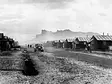
Remnants of that first federal road-building project in
Maryland and Pennsylvania, known as the National Road, still exist along what
is now United States Route 40, says Paul Daniel Marriott, associate professor
of landscape architecture at Penn State University and the author of Saving Historic Roads: Design and Policy Guidelines (John Wiley & Sons, 1998).
Though many drive the route today out of nostalgia, it also represents the early use of engineering techniques including the McAdams method, the precursor of what we now call “macadam.” “The toll houses and bridges were utilitarian in the day, but today they are romanticized,” says Marriott. “It is pleasurable because it represents a different era.”
Stay connected with us via email. Sign up today.
While the National Road once showcased the height of road-building technology, it was quickly replaced by the railroad as a more reliable method of transportation. Clay Kilgore, executive director of Pennsylvania’s Washington County Historical Society, says it wasn’t until the prominence of automobiles in the 1930s through the 1950s that the highway became well known as part of Route 40. This route typically overlaid the old National Road’s original alignment but cut out many of the switchbacks that had been necessary for horse-drawn carriages and carts.
Because of the Route 40 updates, it is now impossible to drive all of the original road, but stretches of it and many historic landmarks along the way are included in the National Register of Historic Places, including milestone markers, Casselman Bridge in Garrett County, Maryland, and the former trading post of Nemacolin Castle in Brownsville, Pennsylvania. Kilgore recommends visiting Brownsville, which he says feels mostly historically intact, as well as the F. Julius LeMoyne House, a National Historic Landmark and stop on the Underground Railroad in Washington, Pennsylvania. (As of press time, the house was temporarily closed for a preservation project.)

photo by: Christopher Bellette/Alamy Stock Photo
A vista of pre-contact era taro fields seen from the Hāna Highway.
Along the northeastern coast of Maui, the Hāna Highway is also noted for its engineering, and, says Marriott, “it is breathtakingly scenic by virtue of its location.” The Hāna Highway features more than 600 twists and turns through lush forest, often hugging the coastline. It crosses dozens of streams and rivers by way of 59 historic bridges, most of which are single lane. Essentially overlaying a pathway developed in the 16th century to connect the many villages in the kingdom of Chief Piʻilani, today the road is a designated Millennium Legacy Trail and is listed on the National Register, connecting the towns of Kahului and Hāna. “Some of that original trail can still be seen today,” says Kauʻi Kanakaʻole, executive director of Ala Kukui, a retreat center in Hāna. “We use it as a hiking trail in Hāna, for example.”
As you travel the modern road, which was established during the sugar plantation era of the late 1800s, “the whole length of the Hāna Highway is steeped in myth and legend,” says Kanaka'ole. “Every valley holds a story; the place names are related to everything from the shapes of valleys to what is grown there.” About two-thirds of the way between Kahului and Hāna, you can see the Ke'anae Peninsula taro fields and the old terraces for cultivating taro. “The peninsula developed when people brought lava rock and soil down from the mountains to the coast to construct the terraces,” says Kanaka'ole.
The Ke'anae viewpoint overlooking the fields and the dramatic coastline has good parking, but along most of the route there are no legal places to pull over, and Kanaka'ole offers simple tips for driving the road as a tourist. First, let the locals pass you. This is the only road for people in the area to use for going about their daily routine. Similarly, don’t stop unless there is a parking lot. “If you see cars along the highway stopped, they are stopped illegally and creating a safety hazard,” says Kanaka'ole. In addition to the overlook at Ke'anae Peninsula, there are only three places to stop that have scenic views, parking lots, and public bathrooms—Kaumahina State Wayside, Pua'a Ka'a State Wayside, and Wailua Valley State Wayside, a pull-off looking up toward Haleakalā.
Once you’ve reached Hāna, you’ll find a remote and rural coastal town of 1,500 people that offers visitors a contrast to the bustling, developed tourist areas on the island. The Hāna Cultural Center & Museum is temporarily closed, but it typically offers tours of some of the oldest buildings on Maui.

photo by: Chuck Pefley/Alamy Stock Photo
For most of its alignment, Montana's Route 2 "Hi-Line" follows the former Great Northern Railway.
Like the National Road, Montana’s Route 2 “Hi-Line” developed out of necessity; for nearly 667 miles, it closely follows the northernmost railroad in the United States. Chere Jiusto, executive director of Preserve Montana, says that Route 2 offers travelers a glimpse back in time at landscapes that remain largely untouched. “Towns along Route 2 are strung like beads on a chain that developed along with the railroad,” says Jiusto. “It’s a trip through rural, agricultural, and tribal heartlands.”
On any given day along the Hi-Line, travelers are sure to see herds of antelope and deer, as well as random coyotes. For those desiring a counterpoint to nature, Jiusto recommends the Museum of the Plains Indian in Browning and Havre Beneath the Streets, a tour re-creating a time in 1904 when the town of Havre was destroyed by fire and business owners moved underground during the rebuilding process. Jiusto also recommends Wahkpa Chu'gn Buffalo Jump, a cliff formation used thousands of years ago by native peoples for hunting bison. “There are more buffalo jumps in Montana than any other state,” says Jiusto, “and Wahkpa Chu'gn is one of the most readily accessible.”
If you are driving the Hi-Line, you don’t want to miss Going-to-the-Sun Road in Glacier National Park, less than a mile north of the route. “Going-to-the-Sun was built purely for pleasure, unlike the National Road, which was built for transportation and commerce. In the 1920s, the idea of people traveling in vehicles to look at scenery was a very new idea, and the road was part of democratizing access to national parks,” says Marriott.
Jiusto focuses on Going-to-the-Sun as “an incredible engineering feat in its day. Even today, the conditions are harsh,” she says. The entire road is typically only open mid-June through mid-October (although parts of it remain open all year), so plan accordingly if you are interested in what naturalist John Muir called “the best care-killing scenery on the continent.”

photo by: ZUMA Press, Inc./Alamy Stock Photo
The Edmund Pettus Bridge in Selma, Alabama.
If the Hi-Line offers opportunities to see landscapes much as they have always existed, the Selma to Montgomery National Historic Trail in Alabama is a road worth driving to better understand a complicated and transformational moment in American history. Established by Congress in 1996, this 54-mile-long stretch of Route 80 commemorates the people, events, and route of the 1965 Selma to Montgomery March, a nonviolent protest led by Martin Luther King Jr.
Travelers along the route should start at the Selma Interpretive Center in Selma, Alabama, the official welcome center for the trail. From there follow Route 80, crossing the Edmund Pettus Bridge, and continue on to the Lowndes County Interpretive Center and ultimately the Montgomery Interpretive Center.
Phillip Howard, project manager of the Civil Rights People and Places program at the Conservation Fund, leads the effort to interpret, restore, and preserve places associated with the 1965 march. “While they are not yet open to the public, the three African American–owned farms where marchers camped each evening to rest are marked by signage along the route,” says Howard. Campsite 1 was owned by David Hall, Campsite 2 was owned by Rosie Steele, and Campsite 3 was owned by Robert Gardner.
“These campsites represent incredible bravery. After the march, the [three] elderly farmers were heinously persecuted and intimidated,” says Howard. “Rosie Steele was born in 1889 and widowed … her store was burned down after the march. She lost everything. Robert Gardner’s family had to have FBI protection. Power lines were cut at their home.”
Howard is currently working with the farmers’ families, who still own these properties, on plans to preserve them so people can visit. He hopes the campsites and other landmarks will be open to the public for the 60th anniversary of the march in 2025. “The march led to the Voting Rights Act of 1965, which changed the trajectory of our nation,” says Howard. “It provided a way for America to get closer to the more perfect union we often hear about.”
Save Historic Places That Tell Our Full American Story
When you join the National Trust, you help save historic and culturally significant places nationwide.

.webp)