[Interview] Q&A with Little Bighorn Archaeologist Douglas Scott
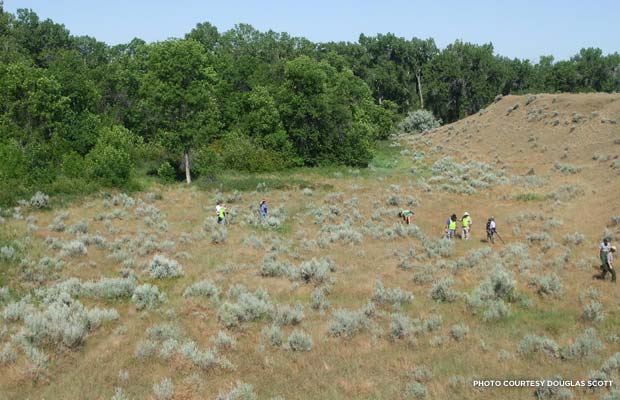
A metal detecting team of National Park rangers and volunteers working near the Little Bighorn River in 2010, the last time Douglas Scott participated in a survey at the site.
In the Winter 2015 issue of Preservation magazine, Logan Ward's story “Common Ground” takes a closer look at an innovative partnership at James Madison’s Montpelier: metal detectorists and archaeologists working side by side to unearth artifacts and dig more deeply into the rich history of our fourth president’s estate.
While this new program is certainly groundbreaking, it’s not without precedent. In 1984, archaeologist Douglas Scott, now retired from the National Park Service, used metal detectors in a large-scale survey of the site of the 1876 Battle of Little Bighorn in eastern Montana. The conflict was a historic showdown between General George Custer’s 7th Calvary Regiment and members of the Lakota, Northern Cheyenne and Arapaho tribes, with the Native American warriors emerging victorious. An estimated 268 U.S. soldiers were killed in the conflict, including General Custer.
With help from more than 30 machine-swinging volunteers, Scott and his partner, Richard Fox, were able to locate more than 5,000 artifacts and accurately map the action of Custer’s Last Stand for the first time ever. Their work at the battleground was one of the first archaeological surveys to employ metal detectors in an organized, systematic way.
I chatted with Scott about the survey, the use of metal detectors as an archaeological tool, and the mystery of the battlefield's Deep Ravine.
What prompted the decision to use metal detectors during the archaeological study of the site of the Battle of Little Bighorn?
It was a bit impromptu – serendipitous, if you will, is probably even a better term. There had been an archaeologist working with a historian – a guy named Robert Bray, working with [historian] Don Rickey. He was the first professional archaeologist to work at the Little Bighorn site. A previous superintendent had asked, during WWII, for archaeological assistance, but nothing was forthcoming because of WWII and other factors until 1958. [Bray] had also worked with an amateur historian called J.W. Vaughn, and they had been using WWII mine detectors. That was one of the first accounts of archaeologists using metal detectors that I am aware of. We knew that there had been work like this done that had been moderately successful.
[In the 1984 study] we established transects and were walking the ground, looking for things. We started walking and looking and found nothing. We said if these people [metal detectorists] want to come along, let’s give it a try. In the first hour, the metal detectors had found 110 artifacts. The grass was less than an inch high, so it wasn’t like we couldn’t see this stuff. It was a paradigm shift – we said, let’s use metal detectors in a very controlled way, and we did it very systematically. Every year for 23 years I did some little project at Little Bighorn, and almost all involved metal detectors. It was a realization that there sites, particularly battlefields, where there are materials that you can't see in the ground.
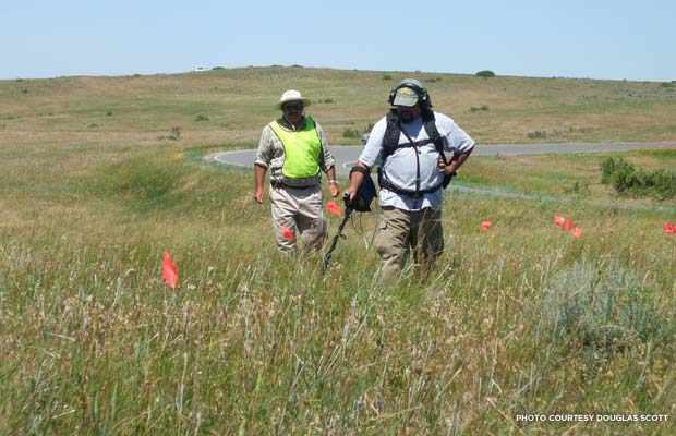
Chris Adams (foreground), an archaeologist with the U.S. Forest service and a volunteer, wields a metal detector while Michael Donahue, a seasonal Little Bighorn Interpretive Ranger, looks on.
I understand that this archaeological study was made possible by a brush fire in 1983 -- how did the brush fire facilitate the excavation?
A careless smoker threw a cigarette out, driving along the highway. It caused a grass fire that burned all this stuff off, about 800 acres at the time. There have been two more fires since then. The good thing about the fires is that they got rid of all the invasive stuff and sagebrush and brought back native grasses, and they moved that vegetation to the point where you actually see the ground. Those were ideal conditions for us, from a metal detecting point of view. We couldn’t have tested that use of metal detectors in a better location at a better time.
What were some of the artifacts that the “diggers” [metal detectorists] were able to turn up at the site?
We suspected that there would be, besides cartridge casings and bullets, equipment left from soldiers' gear, parts of saddles, and personal items. We wondered about whether or not the Native American warriors who fought there would have left anything behind. We did find a few things related to Native American personal paraphernalia, as well as bullets and cartridge casings. We found a copper bracelet and a little ornament actually made out of a few cartridge casings with a little pebble inside it -- probably worn as a necklace on a warrior’s horse. We found saddle parts, buttons, coins, and a total of 50 cents in 5-cent pieces.
How did the artifacts that you unearthed allow you to accurately map the action of Custer’s last stand?
We weren’t sure when we started this what the patterning was likely to tell us. The patterning of those artifacts very definitely showed where the warriors had positioned themselves in order to take advantage of the natural cover -- the rises and falls of the landscape. It was pretty clear that the soldiers took the higher ground and did what they were trained to do. That gave us the ability to see where static events occurred -- where bullets impacted in the ground. That demonstrated to us where events had occurred. People fight the way they’re trained to fight. There was not a lot of movement on the part of the soldiers.
The next step we took with that dataset was a firearms identification, where we compared cartridge cases and what kind of guns they were from. I cross-trained with the Nebraska State Patrol to learn how to do that kind of stuff. When we got done with it, because of the way we’d mapped that site using standard survey techniques, we could then say that Cartridge A and Cartridge B were fired from the same gun. We were able to trace those firearms as they moved across the field. We could see that some of the Native American warriors’ weapons were moving up to a mile around that battlefield. Probably the individuals who were shooting were helping to annihilate the command at one place.
That was probably one of the most exciting things that we came up with. We can definitely see that the Native American warriors outnumbered Custer’s command at least 7 to 1 and outgunned them 2 to 1 -- they outfought Custer. They used the landscape as a more effective means of protection and cover.
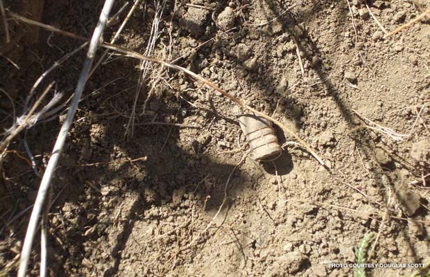
A .45-caliber carbine bullet fired by one of the U.S. soldiers.
Can you tell me a little bit more about the excavation of the “Deep Ravine?”
An alleged 28 men are supposedly buried there, and some later geophysical investigations suggested an anomaly. It’s 10 or 12 feet deep, and they are probably buried one of those very deep areas, based on geomorph study and remote sensing. We did not find anything definitive. The Deep Ravine is a very unstable soil -- right now the vegetation is very fragile, it holds it and keeps it from eroding. Because the soils are so unstable, we would be dealing with hydraulic shoring [an excavation method that involves the use of hydraulic pistons to shore up trench walls,] so it’s not practical, and destructive from an environmental point of view.
Have you used metal detectors in any subsequent excavations or studies?
I’ve worked on about 40 other battlefields all over the United States and all over Europe, sometimes as a volunteer or an advisor. Another project was trying to locate the 1862 camps of the Colorado Infantry, who in March of 1862 saved Colorado and most of the West for the Union after a bunch of Texans came up to take New Mexico and Colorado goldfields that had been in operation since 1851. We started metal detecting in an area that was just absolutely loaded with Civil War-period equipment -- tin cans and you name it. A lot of it was still laying on the surface, so we employed what we call discrimination mode that locates high conductivity targets -- brass, buckles, hooks. At lot more than battlefields can be done using metal detectors.
This was one of the earliest archaeological studies to use metal detectors – how have attitudes about this changed in the archaeological community since 1984?
The 1950s is the earliest I can find, but ours was probably the first to employ it in an extremely organized, systematic manner. We just had an ideal situation, as I mentioned earlier, to do metal detecting and look at patterns. Those were the early days of computerized mapping, and that made tremendous inroads in how we view landscapes today. It was all coming together at that particular point.
We’ve encountered some resistance by some archaeologists to the idea of using metal detectors at all, and there continues to be an attitude that it’s an instrument used by looters. That’s like saying that we shouldn’t use a shovel because looters use shovels. Just because an instrument is used badly by someone else, it doesn’t mean that instrument or tool can’t be used productively using appropriate archaeological supervision and techniques.


