Pacific Time: A Visit to Mendocino County
A road trip in Mendocino County, California, mixes coastal wonders and mill town history.
I arrive at the mouth of the Noyo River at dawn, just as the sky is warming to the earliest signs of day. It’s a harbor I know well, having grown up on this stretch of wild, remote Northern California coast three and a half hours north of San Francisco in rural Mendocino County.
Though the once-bustling port of this former fishing and logging town sees less action than when I was a child in the 1980s, I am relieved to find that Fort Bragg still has a working waterfront, where freshly caught sea urchins are processed in nearby warehouses and fishing boats come and go.
Jeff Laxier, who runs a sea kayaking outfit called Liquid Fusion Kayaking, is already dressed in a thick wetsuit with a tight-fitting hood. He hands me a suit, and I change behind the open door of my car, as the local surfers do. Laxier offers some quick pointers on safety. “If we turn over, which we won’t,” he says with a laugh, “best to let me roll us.” I sign a waiver, and we haul the red tandem kayak to a small gravel beach and shove off.
As we paddle, seals, sweet-faced and dog-like, pop up around us. The ocean here is not placid, but as we slip through a field of sea foam, the sound of the churning Pacific is muted and hushed, deserving—at least for today—of its name.
As we skirt the 50-foot sandstone cliffs, Laxier points to rusted metal “knuckles and rings,” as he calls the remnants of the Fort Bragg mill’s original chute-to-schooner lumber loading system. The 1857 mill was operated by various lumber companies, most recently Georgia-Pacific, and by the time it closed in 2002, logging trucks had long since replaced treacherous schooner transit. Two years ago, after a planning process that took more than eight years, the property opened to the public as Noyo Headlands Park. With it came the new Fort Bragg Coastal Trail, running along headlands that had until then been off limits to all but millworkers.
Before walking the coastal trail, though, I wanted to see my hometown’s waterfront from sea level. In 2000, the entire 1,100-mile stretch of California’s famously photogenic coast—exposed reefs, rocky pinnacles, and rugged islands, from the shoreline to 12 nautical miles out into the Pacific—was declared a National Monument. Viewed by everyone who stands on one of the state’s many beaches and looks out to sea, it is said to be among the most seen but least recognized of the country’s national monuments. In March 2014, that expansive offshore area became significantly more accessible when President Obama used the Antiquities Act to add land to the existing California Coastal National Monument: the 1,665-acre Point Arena-Stornetta Public Lands, which includes the historic Stornetta ranch property. My plan is to drive south from Fort Bragg to Point Arena, exploring the Mendocino coast as I go.

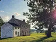
Fort Bragg, established before the Civil War, has always had its own appeal and intriguing backstory. Its moniker refers to a short-lived military post located on the Mendocino Indian Reservation and named after Braxton Bragg, who would later become a Confederate general. Only one structure, a small house north of the Noyo River, remains of the original fort, which was abandoned by the mid-1860s. Before the headlands were a mill site, they served as a seasonal settlement for the Pomo people, who migrated between inland Mendocino County—a hot, dry summertime climate where they harvested acorns—and the coast, where they lived off the fertile ocean, gathering seaweed and mollusks from the rocks and catching salmon. In 1865, the coastal Pomo were subjected to a forced march to another reservation about 80 miles away, and the U.S. government closed the Mendocino Indian Reservation two years later.
During my excursion with Laxier, we see black oystercatchers and cormorants, pelicans and gulls, and an island he dubs “Deer Rock,” because he has often spotted black-tailed deer standing atop it. “They’re great swimmers,” he says, explaining that they feed on the seaweed scattered across the rocks.
After returning from my morning paddle, I meet with Marie Jones, the city’s community development director. Jones is here to show me the southern half of the Fort Bragg Coastal Trail property, which is part of the old mill site. (This portion of the trail opened to the public in December 2015.) At its peak, Fort Bragg’s mill was the largest one on the Mendocino Coast. Operating 24 hours a day, it employed 2,000 people, about a third of the town’s current population. The property’s past is littered with intrigue as well as tragedy. Jones points to a small rocky island wearing a toupee of grass. It was once home to “a house of ill repute,” she says. “The legend goes that one night the women [of Fort Bragg] got together and burned the bridge to the island.”
While much of the mill has been dismantled, a few significant structures were spared. Jones points to a dynamite shack that stored explosives used to break up logjams in the river. Then there is “Dry Shed #4,” a sturdily constructed warehouse that the town hopes to convert to an industrial arts center. The idea is that it would draw artists from around the world to work in glass, pottery, welding, and woodworking.
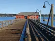
In the days before strict environmental laws, the town’s trash was dumped directly off the headlands and into the ocean. The result, ironically, is one of Fort Bragg’s biggest tourist attractions, Glass Beach, a cove now carpeted with ocean-weathered sea glass. When I was a kid, the chunks were as large as my palm and came in shades as varied as a case of crayons. But after years of glass being pocketed for souvenirs, the collection has shrunk significantly. While a law to protect the prized debris from prospectors passed last fall, the effort seems too late. A more striking reminder of the city’s industrial past is just a quarter mile north, where 44-foot-high Pudding Creek Trestle, once used for log transport and now a pedestrian and bicycle bridge, crosses over a local creek and its wide beach.

From left: Pudding Creek Trestle; a view of downtown Mendocino.

Glass Beach in Fort Bragg.

The MacCallum House in Mendocino.

Point Arena-Stornetta Public Lands.

Downtown Elk.

Inside the Elk Store, open since 1927.
Rather than staying in Fort Bragg proper, I opt for a room 12 miles north of town at the area’s newest hotel, The Inn at Newport Ranch. Before it was a cattle ranch, this historic 2,000-acre property was rich with old-growth redwoods and housed Newport and Kibesillah, two of the dozens of mill towns—complete with stores, homes, hotels, brothels, and bars—that sprang up along the Mendocino Coast in the 1800s.
San Francisco timber interests discovered the giant trees—and their beautiful, rot-resistant wood—while searching for the remains of a trade ship that sank off the Mendocino Coast in 1850. The wreck of the Frolic coincided with the height of the California Gold Rush. As a result, many of San Francisco’s famous “painted ladies”—gorgeous, elaborate Queen Anne Victorians—were built of Mendocino lumber. When the supply of trees dwindled, entire towns disappeared. “As the timber was cut,” says innkeeper Creighton Smith, “the towns would actually move.”
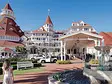
A couple of days later, local author Molly Dwyer and I sit in brightly painted Adirondack chairs on the lawn of the MacCallum House, an elegant yet imposing Victorian home that’s now a bed-and-breakfast, restaurant, bar, and local institution in Mendocino village, 7 miles south of Fort Bragg. Mendocino is the best known and most thoroughly preserved of the coast’s former timber towns, and the Mac House, as it’s known, is its de facto centerpiece. Dwyer had agreed to discuss her recent research on the lives of women in Mendocino’s early days with me, and tells me all about the Mac House’s history. It was built in what was then called the “Pointed Cottage” style as a wedding gift from mill executive William Kelley to his daughter Daisy in 1882. The house used to sit further back from the road, explains Dwyer, but after being badly damaged during the 1906 earthquake, it was moved during repairs.

The still-operational Point Arena Lighthouse stands tall at the end of a narrow peninsula.
Heading south from Mendocino village, Highway 1 winds through a series of communities with names such as Little River, Albion, and Elk. All were once towns in their own right, but today they are fiercely proud enclaves with old post offices, lone gas stations, and a few excellent hotels and restaurants serving mostly tourist traffic. In Elk, also known as Greenwood, I stay the night at the Elk Cove Inn & Spa, built in 1883 as a Craftsman-style house looking out over the jagged shark-fin rock at Greenwood State Beach. Once a timber town of more than 2,000 people, Elk has a market, a scattering of homes, an Irish pub, the beloved Queenie’s Roadhouse Cafe (a former livery stable and Studebaker car showroom), and a population of fewer than 300. The original post office is now a small but impressive museum filled with artifacts from the town’s heyday in the late 1800s and early 1900s.
South of the Navarro River, most visitors returning to the Bay Area turn inland to the straighter, quicker Highway 101. Even having grown up here, I’d driven south of Elk fewer than a dozen times. But it is along Mendocino’s less-populated south coast that the shoreline is at its most dramatic and thrilling. The bluffs rise to more than 100 feet, sheer cliffs cutting to the Pacific at what look like 90-degree angles. They’re topped with wind-sculpted cypress and face offshore islands carved with arches, caves, and blowholes.
Just north of Point Arena, the ranchland once owned by the locally prominent Stornetta family is striking not only in its beauty, but in its varied landscape—from hidden beaches and bizarre washboard rock formations to flat-topped islands and the Garcia River estuary, where the Pomo people fished for Coho and Chinook salmon. The Point Arena Lighthouse stands tall at the end of a narrow peninsula, still operational and open to the public. The 115-foot tower, originally built in 1870 and rebuilt after the 1906 earthquake, is one of the tallest lighthouses on the West Coast.
The building’s spectacular, bedroom-size glass lens has been replaced with a much smaller, modern beacon, but the original sits on display in the former signal house, now a museum. On clear days, the view from the top of the tower is even more impressive than its kaleidoscopic lens.
Today, the Point Arena-Stornetta Public Lands support threatened and endangered species such as the Point Arena mountain beaver, Behren’s silverspot butterfly, and the California red-legged frog. But on the day of my visit, its most colorful characters are a young bride and groom dashing with their raucous, purple-clad wedding party for the edge of a cliff, where they pose for photos against the epic backdrop of one of the country’s newest national monuments.Even on a calm day, the waves crash against the gnarled headlands, a reminder of the Pacific’s remarkable capacity for shaping the California coast into a magnificent, 1,100-mile-long sculpture garden.
Online Extra: Mendocino's Kwan Tai Temple

This historic Chinese Taoist temple in Mendocino received an award from the National Trust in 2002, and is a must-see for anyone exploring the region's multicultural history.