Discover America's 11 Most Endangered Historic Places for 2026
Two hundred and fifty years ago, the United States of America was founded on the principle that all people are created equal. This year, the National Trust’s annual list of America's 11 Most Endangered Historic Places honors that self-evident truth. The histories of these places, and the efforts being made to preserve them today, represent the resilience of remarkable individuals who believe in America’s great promise of equality.
Now in its 39th year, the list has proven to be a highly effective tool for shining a light on the threats facing our nation’s greatest treasures. Due to the efforts of the National Trust and its passionate supporters, the ongoing initiative has galvanized public support behind more than 350 sites to date with only a handful lost.
The 11 Most Endangered program uplifts and catalyzes community-led preservation work through a high-impact public awareness campaign resulting in increased visibility, public attention, and new resources to save and activate historic places for the public good. This year, in honor of the 250th, each site featured on the list will also receive a one-time grant of $25,000 from the National Trust.
The places featured on the 2026 list of America’s 11 Most Endangered Historic Places span the country, from rural areas to densely populated city centers. Each of these places has different challenges and needs, but they are all united in how they illuminate stories of remarkable individuals who fought to bring our country closer to its founding aspirations of equality. These historic places, and the inspiring stories they preserve, are necessary so that America may learn from its past in the hopes of building a more perfect union.
The Ben Moore Hotel (Montgomery, Alabama)
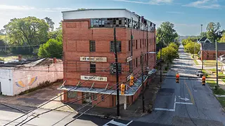
photo by: The Conservation Fund | Jay Brittain
The Ben Moore Hotel, Montgomery, AL
Once frequented by Civil Rights leaders including Dr. Martin Luther King Jr., the Ben Moore Hotel in Montgomery, Alabama was a cultural refuge for Black Americans facing the restricted realities of daily life under Jim Crow. The Black-owned hotel created a space for the Black community to assert their humanity, agency, and right to participate fully in American culture and leisure.
The Ben Moore Hotel helps bridge the gap between American founding ideals and lived experiences, reminding the nation that equality has always required both resistance to injustice and institution-building rooted in dignity and self-determination. The Ben Moore Hotel, built by Matthew Franklin Moore, formally opened in 1951 and was named after the proprietor's father, who had formerly been enslaved. Located in the historic Centennial Hill neighborhood, it was a hub for Montgomery’s Black community, and the hotel was listed in the Green Book as a safe haven for Black travelers barred from white-owned hotels. The building housed a wide set of iconic institutions, including the Majestic Café, the Malden Brothers Barber Shop, and the rooftop Afro Club, which hosted performers including Billie Holiday, B.B. King, Little Richard, and Tina Turner. Located near many other nationally significant Civil Rights sites, including the Dexter Avenue Baptist Church parsonage, the Aurelia Browder Home, the Dr. Richard Harris House and carpool pickup stops during the Montgomery Bus Boycott, the hotel tells an earlier story of the Black institution-building that made Civil Rights organizing possible.
Over time, disinvestment, changing travel patterns, and structural racism led to the decline of many Black-owned hotels, including the Ben Moore. Today, the hotel is not open to the public, and years of vacancy have led to structural deterioration, including water intrusion. As deterioration progresses, the cost of rehabilitation increases significantly, making preservation efforts more difficult and less financially feasible. Development pressures in the neighborhood pose a more complex threat. While the hotel is located in the historic Centennial Hill Historic District, the building is not locally protected to prevent demolition or non-compatible renovations.
In 2025, The Conservation Fund (TCF) acquired the Ben Moore Hotel to prevent demolition and enable initial stabilization. However, additional investment and partnerships are required to reestablish the hotel’s use, rehabilitate the structure, and transition it to long-term community-centered stewardship. TCF is working with the Landmarks Foundation of Montgomery and the City of Montgomery to begin community conversations about the future use of the hotel and identify the immediate stabilization needs. Reuse ideas include a reopened Majestic Café and barber shop, community-serving office space, restored hotel rooms, and a revived Afro Club that would serve as a cultural venue. Rehabilitation of this scope will require a combination of public-private partnerships, historic tax credits, and philanthropic investment. Revitalization of the Ben Moore Hotel would illuminate the hotel as a symbol of African American perseverance and enterprise and allow for public interpretation focused on Black travel during Jim Crow, Green Book sites, African American entrepreneurship, and Montgomery’s broader Civil Rights landscape.
See more photos of The Ben Moore Hotel.
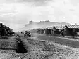
Tule Lake Segregation Center (Modoc County, California)
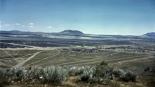
photo by: Public Domain
Tule Lake Segregation Center, 1942.
Tule Lake Segregation Center stands as a testament to the resilience of thousands of Japanese Americans who exercised their rights to protest and resist in the face of racial discrimination, incarceration, and direct attacks on their identities as American citizens. Beginning in 1942, the federal government forcibly removed over 126,000 people of Japanese descent—two-thirds of whom were American citizens—from their homes and incarcerated them at sites like Tule Lake. Today, Tule Lake is a place that honors the brave contributions of Japanese Americans who fought to protect the sanctity of the U.S. Constitution.
From 1943-1946, Tule Lake Segregation Center served as a maximum-security prison for Japanese Americans who protested race-based incarceration by refusing to answer or answering “no” to a government issued “loyalty” questionnaire. For many incarcerated at Tule Lake, their questionnaire responses served as a form of peaceful resistance against a federal government that had violated their right to due process. Later, over 5,000 U.S. citizens incarcerated at Tule Lake renounced their citizenship under duress, in many cases fearing for their safety and the safety of their families after the war. Thousands of people, including children, were deported to Japan. Most deportees eventually sought restoration of their U.S. citizenship, which was only granted after a long legal battle.
Today, a token 37-acre portion of the Tule Lake Segregation Center has been designated as a National Monument, but the primary 1,100-acre site is unprotected. For the survivors and descendants of those incarcerated there, the entire Tule Lake site is sacred ground, a place of suffering, where 331 prisoners died. It is a place of community pilgrimage and private contemplation, yet staffing and public access is limited, and there is no adequate facility for larger groups to gather. After World War II, the majority of the Segregation Center’s structures were demolished or removed, and a rural airfield now occupies 359 acres at the heart of the former incarceration camp site. The Federal Aviation Authority and Modoc County are seeking to construct a 3-mile long, 8- to 10-foot-high security fence around the airfield, which could permanently alter the setting, viewshed, and archaeological integrity of Tule Lake. Survivors and descendants believe the airfield desecrates this sacred site.
The Tule Lake Committee, an organization of survivors and descendants whose families were incarcerated at Tule Lake, is leading advocacy efforts to relocate the airfield from this sacred place. Protecting this American civil rights site would honor the people who resisted injustice here and provide opportunities to expand public visitation and interpretation at the National Monument. In partnership with groups including the National Trust, APAIHiP, NPCA, Japanese American Confinement Sites Consortium, Congressional Asian Pacific American Caucus, and others, the Committee has generated over 38,000 public comments in opposition to the proposed fence. Additional partnerships and support will be needed to ensure Tule Lake can be protected and its stories of resilience can be shared with future generations on the sacred site where thousands of American citizens bravely advocated for their rights.
See more photos of Tule Lake Segregation Center.
Urge your members of Congress to support the Tule Lake National Monument.
Angel Island Immigration Station (Tiburon, California)
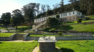
photo by: Angel Island Immigration Station Foundation
Angel Island Immigration Station, former detention barracks.
Located in the middle of the San Francisco Bay, the Angel Island Immigration Station stands as a reminder that the United States—a nation to which generations of immigrants have contributed—has at times implemented unjust policies toward those pursuing entry into the country. Built to enforce racially exclusionary immigration laws, the station detained more than 300,000 immigrants, primarily from Asia and across the Pacific. While Ellis Island is remembered as a gateway of welcome, Angel Island tells a different story of lengthy interrogations, months or even years of detention, invasive medical exams, and family separation. Diving deeper into these histories, visitors will also find courageous stories of resilience, hope, and determination. The Angel Island Immigration Station allows visitors to experience its vital history through the perspective of immigrants and serves as a visceral reminder of our obligation now to honor the ideal of that all are created equal and to continue the work of building a more perfect union.
At its peak, the Angel Island Immigration Station was the busiest immigration port on the West Coast, processing approximately 1,000,000 people between 1910 and 1940. More than 300,000 people from 80 different countries (mainly China, Japan, and other Asian Pacific Island countries) were unjustly detained on the island, many due to their race. When the immigration station closed in 1940, the site was used to detain 700 civilians of Japanese heritage living in Hawai’i and California, and served as a prisoner of war processing facility during World War II. In 1963, Angel Island became part of the California State Park system.
More than 200 poems carved into the detention barracks walls by the immigrant detainees ultimately helped to save the buildings. These poems provide a rare first-person testimony of detainees’ experiences and emotions and inspired a grassroots advocacy movement to save the buildings from demolition in the early 1970s. In 1997, Angel Island Immigration Station became a designated National Historic Landmark. After the site was previously included on the 11 Most list in 1999, California State Parks and the Angel Island Immigration Station Foundation (AIISF) partnered to restore the detention barracks and the hospital, which are now open to the public as a historic site.
Although the detention barracks and hospital were successfully rehabilitated, they require ongoing maintenance in order to serve visitors’ needs. Several other historic structures on the island are deteriorating, including the powerhouse, mule barn, and World War II-era barracks. Due to its island location, the immigration station is subjected to constant wind and weather. Heavy rain has caused leaks in the elevators, restricting handicap accessibility, and wildfires scorched more than half of the island in 2008. Additionally, the current environment of heightened immigration enforcement has prompted some community members and school groups to reconsider their engagement with the site out of concern and consideration for students and community members who may have previously experienced immigration raids or detention, highlighting the political and social pressures that may affect Angel Island’s long-term stability.
The AIISF was founded in 1983 by descendants of Angel Island detainees and works closely with Angel Island State Park to manage preservation, interpretation, and programming at the site. Approximately 23,000 people visit the immigration station each year, but this is a fraction of the number of visits to nearby Alcatraz. Additional financial investment and expanded marketing efforts could help increase visitation, improve accessibility, enhance interpretation, and increase public attention.
See more photos of Angel Island Immigration Station.
Swansea Friends Meeting House (Somerset, Massachusetts)
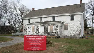
photo by: Richard Peirce
Swansea Friends Meeting House, Somerset, Massachusetts.
The Swansea Friends Meeting House in Somerset is recognized as the oldest surviving Quaker meeting house in Massachusetts and tells the story of how early Quaker settlers struggled for religious freedom and safety. Rooted in the Quaker belief of “Inner Light,” which emphasizes spiritual equality and universal dignity, the meeting house was an important site where these ideals were discussed and applied to the abolition movement and the expansion of women’s roles within the church. Today, the Meeting House stands as a powerful reminder of the tireless pursuit of equality for all.
The geographic area of Somerset (once Swansea) largely consisted of the ancient Shawomet lands of the Pokanoket Tribe, which were sold by the Plymouth Colony to finance King Philip’s War. Due to religious persecution, the early Quaker community settled in this area because of its proximity to the Rhode Island border, where religious freedom was supported by colony leaders. The original Meeting House was built between 1701-1702, and additions were made in 1742, 1872, and 1889. The founders of the Meeting House had a significant influence on the struggle for religious liberty in Massachusetts, with their advocacy resulting in a new state law exempting Quakers from being taxed for the support of Puritan ministers. The Quaker belief in equality provided an opportunity for Patience Brayton to serve as an early female minister of the congregation from 1760-1794. Minister Brayton is considered to be the driving force behind Swansea becoming one of the earliest towns in Massachusetts to abolish slavery. Between 1771-1783, Minister Brayton traveled to eight American colonies, Great Britain, and Ireland to preach and promote the abolition of African American and Native American slavery.
After the remaining members of the small Quaker congregation conveyed the Meeting House to the Town of Somerset in 2008, the building was no longer in regular use for almost a decade and began to deteriorate. In 2017, a group of Somerset residents committed to preserving Somerset history and the Meeting House established an organization called the Friends of Somerset Historic Preservation (FOSHP), which took emergency action to stabilize the building and replace the roof. Today, the Meeting House is not open to the public and needs significant interior and exterior rehabilitation, requiring substantial funding and expertise.
Exterior repair work funded by the Massachusetts Historical Commission, the Town of Somerset, and other private sources is now underway, but more than $1 million in additional funding will be needed to complete the exterior and interior restoration, make the building accessible, and add interpretive materials. Once restored, FOSHP plans to open the Meeting House to the public as a community cultural center. As a key location within the proposed Sowams National Heritage Area, activating the Meeting House to serve the public would promote regional history and tourism, and illuminate the Quakers’ significant role the pursuit of religious freedom, abolition of slavery, and women’s rights.
See more photos of Swansea Friends Meeting House.
Detroit Association of Women’s Clubs (Detroit, Michigan)
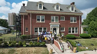
photo by: Akil Clark, Clark Tek LLC
Detroit Association of Women’s Clubs, Arise Detroit, community service volunteer day, 2023.
In 1941, nationally recognized Civil Rights leader Dr. Rosa Slade Gragg took tremendous personal and financial risk to secure the headquarters building for the Detroit Association of Women’s Clubs (DAWC) during her presidency of the organization; to avoid the racially restrictive clauses prohibiting African Americans from living on certain streets, Slade Gragg had the building’s address officially changed. Dr. Slade Gragg's brave actions ensured that association members would have a home base for community organizing efforts that aimed to create equality for women and Black Americans, and she would go on to continue this work on a national scale, serving as an advisor to three United States Presidents (Roosevelt, Kennedy, and Johnson). During her tenure as president of the National Association of Colored Women’s Clubs (1958-62), Dr. Slade Gragg successfully advocated for legislation designating the Frederick Douglass House in Washington D. C. as a National Historic Site operated by the National Park Service, and she was later in attendance as President Johnson signed the Civil Rights Act on July 2, 1964.
The DAWC was founded as part of the Black uplift movement of the early 20th century to “promote charitable, educational, religious, social activities, and community uplift, and to aid in the solution of racial problems.” The DAWC began with eight clubs; membership peaked in 1945 with 75 clubs and 3,000 members. Throughout its history, the DAWC has hosted weddings, receptions, recitals, and cotillions in the clubhouse, becoming a significant part of Black Detroiters’ social lives. The DAWC’s service to its community has been significant, leading initiatives including scholarships, clothing drives, community clean-ups, food distributions, and literacy programming.
In February 2024, burst water pipes in the DAWC clubhouse caused damage to interior finishes and led to closure of the building to association members and the public. Two years later, the building remains unusable. While engineers have confirmed that the clubhouse is structurally sound, the DAWC needs significant financial support to repair the water damage and to address other necessary improvements including interior and exterior rehabilitation, accessibility and energy efficiency.
Not having the ability to operate from their headquarters building has limited the programs and social support services that DAWC can provide to their community. Having a physical space where Black women could safely go in person for social connection and community organization was integral to the founding of DAWC and remains critical today. The DAWC and the City of Detroit worked together to add the clubhouse to the National Register of Historic Places and are collaborating to develop a Historic Structure Report, funded by a grant from the National Park Service, which will provide a roadmap for restoring the clubhouse, but partnerships and financial support are needed to ensure the DAWC is reopened to members and the public for community-serving programs and initiatives.
See more photos of Detroit Association of Women’s Clubs.
Greater Chaco Cultural Landscape (New Mexico, Colorado, Arizona & Utah)
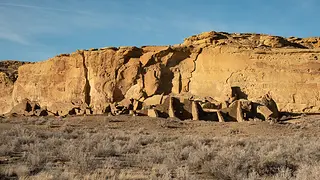
photo by: Avi Farber
Pueblo Bonito in the Chaco Culture National Historical Park, New Mexico.
The Greater Chaco Cultural Landscape, an ancestral homeland sustained by Pueblo people for over a millennium, is a place of deep meaning for modern Pueblo and Hopi nations. Actions to safeguard public land and respond to ongoing threats like industrial development are part of a broader history of American land, including the dispossession and destruction of Indigenous sites. Those organizing to protect this landscape demonstrate that Indigenous histories and enduring relationships with the land are not secondary to economic gain, but rather essential, equal, and permanent threads in American history.
Encompassing thousands of square miles across northwestern New Mexico and extending into Arizona, Colorado, and Utah, the Greater Chaco Cultural Landscape includes federal lands such as the Chaco Culture National Historical Park, state trust lands, tribal lands, and private lands. While best known for its monumental stone houses built between 850 and 1250 A.D., the significance of Chaco lies in the vast system of communities it connected across what is now northwest New Mexico and beyond, and it remains an ancestral homeland and place of ongoing cultural and ceremonial importance for today’s Pueblo and Hopi nations. Its architecture and famed petroglyphs (aligned to solar and lunar cycles) illuminate oral traditions passed down through generations, maintaining vital links to ancestors. The site also serves educators, researchers, and visitors, seeking a fuller understanding of world history, including at Acoma Sky City, which is a National Trust Historic Site owned and operated by Pueblo of Acoma. Pueblo of Acoma is a member of the All Pueblo Council of Governors, a collective voice of the 20 Pueblo Nations of New Mexico and Texas that has long advocated to protect this significant area. The landscape also provides critical context for understanding related ancestral sites across the region, including Mesa Verde National Park, Aztec Ruins National Monument, and Bears Ears National Monument, reflecting a broader interconnected system rather than isolated places.
Federal and state management of the cultural landscape have historically treated Chaco as an isolated archaeological park, ignoring the broader landscape and the living Indigenous communities who continue to hold cultural responsibilities to these places. This fragmented approach has left the majority of Greater Chaco vulnerable to industrial development and irreversible damage. In 2025, the federal administration initiated the process to fully revoke Public Land Order (PLO) No. 7923, which had placed a ban on new leasing for gas and mineral extraction. Without the PLO, lands outside the protected park boundaries could open to oil and gas development, damaging the integrity of the landscape and limiting continued cultural access and use by Pueblo communities.
If protected and interpreted holistically, the Greater Chaco Cultural Landscape could serve as a national model for Indigenous-led stewardship, intertribal collaboration, and public education grounded in respect and consent. Permanent protections, restoration of robust tribal consultation, coordinated land-use planning, and recognition of the landscape as a living place are all essential strategies to save the landscape. The public can support protections for the Greater Chaco Cultural Landscape by asking their representatives in Congress to support the Chaco Culture Heritage Areas Protection Act and oppose policies to rescind PLO No. 7923.
See more photos of Greater Chaco Cultural Landscape.
Urge your members of Congress to support the preservation of the Greater Chaco Cultural Landscape.
Women’s Rights National Historical Park (Seneca Falls, New York)
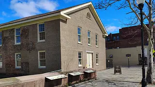
photo by: April Hall
Wesleyan Chapel, Women’s Rights National Historical Park.
At the Wesleyan Chapel in 1848, approximately 300 people gathered for the first formal convention in the United States dedicated to the rights of women. Here, the Declaration of Sentiments was drafted and signed, a foundational document that was modeled after the Declaration of Independence and that boldly asserted “all men and women are created equal.”
The Women’s Rights National Historical Park reflects this push to expand the definition of equality to encompass all people in the United States. Through its assembled properties, the national park tells the essential narrative of the early struggle for women’s rights and autonomy, and connects that story to the ongoing, multi-generational fight for civil rights, human rights, and economic justice for all. In addition to the Wesleyan Chapel, the WRNHP comprises four non-contiguous sites in Seneca Falls and Waterloo, New York, including the homes of three 19th-century reformers -- Elizabeth Cady Stanton, Mary Ann M’Clintock, and Jane Hunt.
Today, a lack of funding is threatening these crucial pieces of American heritage. According to a 2025 infrastructure fact sheet (PDF) released by the National Park Service (NPS), Women’s Rights National Historical Park is facing over $10 million in deferred maintenance and needed repairs, including restoration of the 1847 Elizabeth Cady Stanton House; upkeep and maintenance of the 1843 Wesleyan Chapel; rehabilitation of the 1829 Hunt House; and maintenance and repairs at Declaration Park and the Water Wall. Over the past year, staffing at the park has been reduced and programming has been impacted by a lack of funding.
Women’s Rights National Historical Park is one of fewer than 15 NPS units created in recognition of women’s history and achievement, out of 433 total NPS units. This overall lack of representation of women’s history within the National Park system makes it crucial to ensure that this park has the funding and support needed to restore historic resources, provide public interpretation, fully share the significant stories embodied here with the American public, and inspire new generations to continue the fight for full representation and equality. The nonprofit Friends of Women’s Rights National Historical Park works closely with the park to provide support for educational efforts and events. In 2027, the NPS will be investing $1.8 million in an upgraded HVAC system in the Visitor’s Center. While these repairs are much needed, Women’s Rights National Historical Park will need financial assistance to support temporary facilities for visitors and educational programming during construction. Significantly more funding will be needed to allow the park to address all of its outstanding maintenance and rehabilitation needs.
See more photos of Women’s Rights National Historical Park.
Ask your Senators to support the Women's Rights National Historical Park through the America the Beautiful Act (S.1547).
Stonewall National Monument (New York, New York)
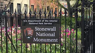
photo by: Timothy Leonard, National Parks Conservation Association
Stonewall National Monument, New York City.
In the summer of 1969, members of New York City’s LGBTQ+ community and allies took a stand, challenging authorities that were unjustly targeting their public and private social spaces and gathering spots. Demonstrators in the multi-night uprising that started at the Stonewall Inn gay bar demanded that their country live up to its values – recognizing their full humanity and extending the promise of equality to groups long marginalized. At Stonewall, American ideals inspired collective action that changed the course of the nation.
The Stonewall Inn gay bar opened in 1967 and served as a vital social refuge for LGBTQ+ New Yorkers, in a moment when this community was experiencing systemic discrimination and police harassment. Two years later, in the early morning hours of June 28, 1969, a routine police raid at the Stonewall Inn triggered an unexpected and historic response. Rather than quietly dispersing, patrons and neighborhood residents resisted. The confrontation grew into several nights of demonstrations centered on the bar and the surrounding blocks. This resistance, now known as the Stonewall Uprising, energized a more visible wave of organizing that included the formation of hundreds of new groups dedicated to the fight for gay liberation, and led directly to the first Pride marches in June 1970. In recognition of this significant history, the land within Christopher Park became federally owned when it was designated in 2016 as the Stonewall National Monument, the only unit of the National Park Service specifically dedicated to LGBTQ+ history. The boundaries of the monument include the streets where the Uprising took place, as well as the two privately owned buildings that once housed the original Stonewall Inn, which closed in 1969. Today, these two buildings have been designated as individual landmarks by the New York City Landmarks Preservation Commission for their significance to LGBTQ+ history and the events of 1969. They remain privately owned and operated, and continue to serve the public and the LGBTQ+ community as the Stonewall Inn bar and the Stonewall National Monument Visitor Center.
By anchoring this history in a specific preserved and protected place, the Stonewall National Monument at Christopher Park helps ground abstract civil rights themes into a tangible public story that visitors can see and experience. The National Monument faces federal actions and policy changes that endanger the site’s historically accurate interpretation, community representation, and educational impact, including the participation of the full range of LGBTQ+ people in the Stonewall Uprising. After recent litigation, the federal government returned the Pride flag to the National Monument. To date, however, interpretative materials referencing transgender historic narratives have not been restored.
Allies and partners are preparing to celebrate the 10th anniversary designation of the National Monument in 2026, including NPCA, Stonewall+, NYC LGBTQ Historic Sites Project, Christopher Park Alliance, Making Gay History, the City of New York, and many others; but sustained advocacy is necessary to ensure that the full and accurate LGBTQ+ history of the Stonewall Uprising remains publicly visible. Stonewall’s history is intertwined with the history of other LGBTQ+ historic sites across the country, so it is essential to safeguard accurate interpretive materials at the National Monument, as well as expand public interpretation and awareness about why the Stonewall Uprising matters, in order to contextualize historic LGBTQ+ places throughout the entire nation.
See more photos of Stonewall National Monument.
The President’s House Site (Philadelphia, Pennsylvania)
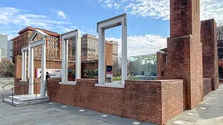
photo by: Michael Bixler
The President’s House Site, Philadelphia, Pennsylvania.
Located in Philadelphia’s Independence National Historical Park, the President’s House archaeological site was the location of the nation’s executive mansion from 1790 to 1800, housing George Washington and John Adams as they established the foundations of American democracy. As a historic site, it enables visitors to understand the historical context and contradiction between the principle of freedom and the institution of slavery by displaying the stories of the people who were enslaved within its walls and highlighting their stories of resistance and self-emancipation.
Forgotten for decades and at one point buried beneath a public restroom, the President’s House Site was reclaimed in 2005 and further bolstered in 2007 after archaeological excavations led by the National Park Service uncovered the mansion’s original foundations, cellar, and kitchen. Successful grassroots advocacy by the Avenging the Ancestors Coalition (ATAC) led to the creation of a memorial dedicated to the individuals enslaved by Washington on this site, including Ona Judge and Hercules, who resisted slavery by self-emancipating from this site. In 2010, a new “ghost house” was constructed on the President’s House Site, evoking the memory of the long-lost executive mansion. The structure’s walls were outfitted with panels and video monitors explaining the history of the executive mansion, its role as a site of enslavement, and commemorating the lives of the enslaved people who lived and labored there.
Today, the President’s House Site is endangered by federal actions that undermine its historical significance and public interpretation. Exhibits that formed the interpretive core of the site, allowing visitors to discover the lives of nine enslaved people and conceptualize the nation’s first executive mansion within the broader context of slavery in the early republic, have been removed. Following U.S. District Judge Rufe’s preliminary injunction, a portion of the interpretative panels were temporarily reinstalled.
With millions of people expected to visit Philadelphia during the nation’s 250th year, it is essential that all the interpretive materials be permanently returned to the President’s House Site so that visitors may experience the historical truth of the site through the eyes of the nine enslaved people that lived and labored there. The President’s House/Slavery Memorial Alliance has formed as a broad coalition for groups leading community activism and legal action, including key partners like ATAC and the Preservation Alliance for Greater Philadelphia. Additionally, the coalition aspires to utilize the momentum to identify and recognize other sites where people were enslaved on federal property, furthering the educational impact that historical sites have on Americans’ self-discovery.
See more photos of President’s House Site.
Hanging Rock Revolutionary War Battlefield (Heath Springs, South Carolina)
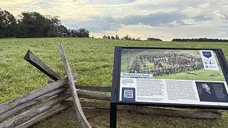
photo by: Phil Gaines
Newly installed interpretive signs on a portion of the Hanging Rock Battlefield owned by the South Carolina Battleground Preservation Trust.
On August 6, 1780, a Patriot militia bolstered by Catawba warriors faced off with British and Loyalist troops at the Battle of Hanging Rock. The fierce three hours of fighting revealed the complex alliances, human cost, and unresolved tensions of the American Revolutionary War, particularly around who the Declaration of Independence’s principles of freedom and equality were meant to serve. At Hanging Rock, neighbors fought over loyalty, land, and self-government, each with distinct stakes in survival and autonomy. The Hanging Rock Battlefield continues to reveal the complexities of the Southern Campaign—including the Revolutionary War experiences of Native Americans, women, and Loyalists living outside major cities occupied by either Patriot or British forces—and offers a powerful opportunity to broaden the story of the American Revolution beyond its most familiar narratives.
After the fall of Charleston in May of 1780, the British established several outposts intending to restore Royal authority over South Carolina’s population and resources. Hanging Rock, located between Camden, SC, and Charlotte, NC, was the most northerly of these British outposts. Patriot General Thomas Sumter led 800 troops of Patriot militia and 40 Catawba warriors into battle against 1,400 British and Loyalist troops commanded by British Major John Carden. Sumter’s troops inflicted significant casualties on the British, and the battle is considered a Patriot victory that helped boost morale at a dark time in the Southern Campaign, ultimately weakening British control in South Carolina. The battle also marked the first wartime experience of a 13-year-old Patriot messenger, future President Andrew Jackson.
Today, only a portion of the 600 core battlefield acres, where intense combat occurred, have been preserved and protected through acquisition for public access and recordation of permanent conservation easements, leaving much of the site vulnerable to alteration. The area is experiencing population growth and development pressures, which risk fragmenting the battlefield’s core acres. Significant funding is needed for land acquisition, park development, and long-term stewardship of the battlefield. These actions would create a space where visitors can further understand the Battle of Hanging Rock’s complexities while standing in the place where it happened.
A coalition led by the American Battlefield Trust and including the South Carolina Battleground Preservation Trust, South Carolina 250 Commission, South Carolina State Parks, and Friends of Hanging Rock, have been working to protect key battlefield land and develop public access improvements at the Hanging Rock Battlefield, including a walking tour and signage. The coalition’s vision is to expand public access, interpretation, and funding to support a sustainable and fully revitalized Hanging Rock Battlefield Park, but more funding and partnerships will be needed.
See more photos of Hanging Rock Revolutionary War Battlefield.
Urge your members of Congress to support American Battlefield Protection Program Amendments Act (H.R. 7618/S. 3524).
El Corazón Sagrado de la Iglesia de Jesús (Ruidosa, Texas)
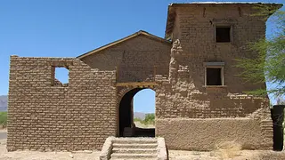
photo by: Sarah Vasquez for Friends of the Ruidosa Church
El Corazón Sagrado de la Iglesia de Jesús in 2020 before Friends of the Ruidosa Church began the preservation and restoration project.
The families who fled the Mexican Revolution and settled in the Texas border town of Rudiosa carved out spaces for themselves within a country that could be selective in its promises of equality. The Mexican American residents there responded to the daily realities of segregated schools, voter disenfranchisement, and wage inequality by organizing as a collective; the construction of El Corazón Sagrado de la Iglesia de Jesús (The Sacred Heart of the Church of Jesus) was a physical manifestation of this resilience, offering a shared sanctuary that came to represent a beacon of hope for a more just and equal future.
Completed in 1915, El Corazón Sagrado Church became the cultural, social, and religious nucleus for the small farming communities that once dotted the borderlands on both sides of the Rio Grande River. An architectural gem, the church is notable for its traditional adobe construction and freestanding adobe arches, which are believed to be the largest remaining in Texas. Within these sacred walls built from the very ground they stand on, Ruidosa’s Mexican American and Mexican communities worshipped, celebrated, and mourned together. By the 1940s, the farming population of Ruidosa began to decline due to a lack of water for irrigation, and El Corazón Sagrado Church began to fall into disrepair.
After the church was abandoned in the 1950s, the adobe began to erode. Water and wind quickly deteriorated the traditional material, as it was no longer receiving regular maintenance. Following years of neglect, local advocacy efforts were successful in preventing demolition, and the Catholic Diocese of El Paso eventually deeded the church to Presidio County, which in turn transferred the property to the nonprofit Friends of the Ruidosa Church in 2019. Today, the Friends regularly host community days and adobe-making workshops, and have now stabilized the bell tower, repaired the roof, and brought water and electricity back to the site. Still, a great deal of work remains to complete the preservation, protection, and reactivation of the building. The church’s interior is open to the elements, and heavy rains cause water to pool, damaging the adobe. And now, a proposed new U.S. border wall is planned to be constructed within a few hundred yards of the church, cutting it off from the Rio Grande River and from communities across the border, and advocates are concerned that vibrations from the heavy construction equipment traveling regularly in close proximity to the church could potentially impact the church’s fragile adobe, particularly the freestanding adobe arches.
The Friends of the Ruidosa Church plan to transform the church and several nearby historic sites into a hub for the small Latine community that remains connected to the church, as well as a vital anchor for the broader community and a central venue for reconnecting people through shared heritage and cultural celebrations. The Friends have completed a Historic Structure Report with funding from the Texas Historical Commission and are exploring the use of historic tax credits to help fund rehabilitation efforts. In 2025, the church was named to the first national list of Endangered Latinx Landmarks by the esteemed nonprofit Latinos in Heritage Conservation, highlighting the value of Latinx history in the broader narrative of American heritage.
See more photos of El Corazón Sagrado de la Iglesia de Jesús.
Our work to save historic places is fueled by the commitment of members and supporters like you, and we are glad to have you as a part of our community! Your donation to the National Trust helps protect the places that tell our full American story.
.webp)